| |
  What
goes in must come out, so the day started with the return trip on the dirt
road to the highway. We weren't the only bicyclists out there so the
road couldn't have been that bad.
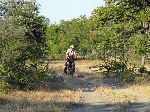
We met a bicyclist with a cooler on his bike who was heading to a lake several
kilometers away to buy fish. What
goes in must come out, so the day started with the return trip on the dirt
road to the highway. We weren't the only bicyclists out there so the
road couldn't have been that bad.
We met a bicyclist with a cooler on his bike who was heading to a lake several
kilometers away to buy fish.
 For
a relatively well populated area there still seemed to be a scarcity of
commercial activity. After Ngoma, the next stores were at 20 km, 30 km and 48 km
up the road. We returned to the highway 15km from Ngoma, so the store at 20 km was well placed for a
breakfast stop. [From later experience, it turns out that this level of retail was frequent.] For
a relatively well populated area there still seemed to be a scarcity of
commercial activity. After Ngoma, the next stores were at 20 km, 30 km and 48 km
up the road. We returned to the highway 15km from Ngoma, so the store at 20 km was well placed for a
breakfast stop. [From later experience, it turns out that this level of retail was frequent.]
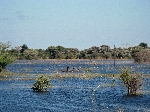 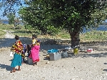 Besides
creating a couple of refuge camps along the road, the high water brought a
lot of people out for some fishing on a Sunday afternoon -- both on land and
in boats -- and the product of their activity was being sold at the side of
the road (right). Besides
creating a couple of refuge camps along the road, the high water brought a
lot of people out for some fishing on a Sunday afternoon -- both on land and
in boats -- and the product of their activity was being sold at the side of
the road (right).
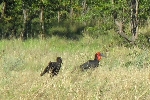 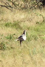 The
high water probably helped the bird watching. It was decently good for bicycle
seat bird watching. Among other
species, we saw ground hornbills (left), hamerkops, lampwing (plover), loury
(go-away-bird), a secretary bird (right), lilac breasted rollers, starlings, bateleur and several other varieties of hornbill. The
high water probably helped the bird watching. It was decently good for bicycle
seat bird watching. Among other
species, we saw ground hornbills (left), hamerkops, lampwing (plover), loury
(go-away-bird), a secretary bird (right), lilac breasted rollers, starlings, bateleur and several other varieties of hornbill.
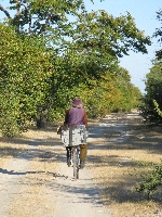
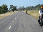  Between
the scattered housing there was a lot of open road with very little traffic.
Generally, Namibia doesn't seem to embrace signs in a big way. Even
schools and other public buildings lack labels, as do churches and many
stores. However, houses frequently have signs naming the family. One
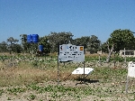
of the few institutional signs we saw highlighted a project on women and development
and food security (right). Between
the scattered housing there was a lot of open road with very little traffic.
Generally, Namibia doesn't seem to embrace signs in a big way. Even
schools and other public buildings lack labels, as do churches and many
stores. However, houses frequently have signs naming the family. One
of the few institutional signs we saw highlighted a project on women and development
and food security (right).
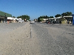 Katima
Mulilo is the biggest town in the Caprivi Strip and more of a town than
Kasane. But even so, the commercial district measured about five linear
blocks. It had a bank, a couple of restaurants, large grocery store,
hardware store, pharmacy, clothing store, traditional market with vendor
stalls, tire shop and the like. Katima
Mulilo is the biggest town in the Caprivi Strip and more of a town than
Kasane. But even so, the commercial district measured about five linear
blocks. It had a bank, a couple of restaurants, large grocery store,
hardware store, pharmacy, clothing store, traditional market with vendor
stalls, tire shop and the like.
 We missed the Internet Friday afternoon and Saturday
morning in Kasane because we arrived late and left too early. The next
likely place to cross paths with modern technology was Katima Mulilo. But the
relatively strong Christian underpinning of the culture had most of the
downtown, including the Internet, tightly "closed Sunday." We missed the Internet Friday afternoon and Saturday
morning in Kasane because we arrived late and left too early. The next
likely place to cross paths with modern technology was Katima Mulilo. But the
relatively strong Christian underpinning of the culture had most of the
downtown, including the Internet, tightly "closed Sunday."
Three days along and we should be learning our third
and forth languages. The dominate ethnic groups in Katima Mulilo are
Fwe or Mafwe (speaking Sefwe) and Lozi (speaking Silozi or Sikoko). The Lozi
ethnic group has its center of its population in Zambia, but their language is still spoken
in this area as a legacy of their domination of the region in the late 1800s. Good morning is "mozuhile
chwang". Good afternoon is "mutozi chwang". And, thank you is "nitumezi."
Sefwe is the largest language group in the Caprivi Strip and is close to
Subia and Totela: Good morning is "mavoka." Good afternoon is "malisala."
We ate dinner at the Take Away near the bus ranks.
The restaurant also had tables and chairs for dine-in customers. Everything
was pre-packaged for clients popping off the long haul buses for a quick meal.
The selection included rice with curried chicken, papa (corn meal boiled
stiff) with chicken, and
spaghetti with a tasty sauce. At least if you dined in the meals would be
heated in a micro-wave and served on a china plate.
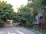 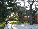 Our
digs for the evening were Mukusi Cabins. The grounds were nicely
wooded and landscaped. The cabins had kitchenettes and were clean and
comfortable. The house keeping staff also provided extraordinarily
fast laundry service -- about two-hour turn-around time. Our
digs for the evening were Mukusi Cabins. The grounds were nicely
wooded and landscaped. The cabins had kitchenettes and were clean and
comfortable. The house keeping staff also provided extraordinarily
fast laundry service -- about two-hour turn-around time.
|
Addendum: The
Makololo:
(Source Sangwali Museum)
The Makololo controlled a
vast area north and south of the Zambezi, including the Caprivi from about
1838 to 1864. Under their chief Sebetoane, they had become one of the
most powerful groups of people in southern Africa.
The story of the Makololo begins in about 1822, when they were
known as the Fokeng, living on their ancestral land at Kurutlele, near
Senekal in the Free State. It was the time of the mefacane or difiquane,
a great
upheaval of people, mainly due to the conquests of the Zulu king Shaka.
Sebetoane became chief of the Fokeng when he was about 20 years
old. At that time they had already had to flee their homes and had crossed
the Vaal River. Sebetoane decided that there would be no peace for his
people in this region and he persuaded them to march north, to find a ‘place
of tranquility’ where they could settle. This march was to take them on a
journey of more than 5, 000 km, through the Kalahari Desert, right into the
kingdom of the Lozi north of the Zambezi.
His first great battle was at Dithakong, June 2823, near Kuruman in the Cape.
Here, for the first time he saw firearms being used by the Griquas against
the large invading army of which he was part. [Before this battle, at this
place, he had had a fight with another people, the Phuting, who had
also been uprooted. Sebetoane won and amongst the prisoners that he took
was a young woman of the Kollo clan called Setloutlou. He later took her
as his wife. She was the mother of Sekeletu who, much later, succeeded
Sebetoane as chief. Tradition says that because Sebetoane favored her so
much, his people became known as the Makollo or Makololo.] (cont)
|
|
The Makololo (cont) After the battle
at Dithakong, Sebetoane fled the area and
started his long journey north with his people. He had already encountered
the power of Mzilikazi and his Ndebele people who were also fleeing from
Shaka (along with other groups, led by ex-generals of Shaka, destined for
Mozambique and Malawi).
Sebetoane fought his way through the land of many other tribes as
he proceeded north across what is now Botswana. He defeated the Kwena
in 1825. Continuing north, he fought his way
through the land of the Hurutse and near Serowe he encountered the Ngwato
who, after a battle, fled west to Lake Ngami. Entering the country of the
Kalaka, Sebetoane also turned his followers west, across the thirsty lands
of the Kalahari. He settled for a while again at Lake Kamadou near Rakops
before uprooting and continuing to Lake Ngami. Here he defeated Moremi, who
took his Tswana people north and settled here at
Sangwali, which he called
Tshoroga.
Sebetoane realized there was no peace in this region. It was also
unhealthy, his people were dying of fever and his cattle were being bitten
by the tsetse fly. He took his followers north through the Okavango Delta,
then turned east and entered the Linyanti marshes. He launched a surprise
attack on the Ngwato, defeated them and made them one of
his subject tribes. He made Sangwali his capital, but re-named it Linyanti.
After two years he realized that the marshes were too unhealthy and he
continued north. He crossed the Zambezi near Kazangula, west of the
Victoria Falls. He settled for a while on the healthy and fertile Batoka
Plains.
Alas, he was not to enjoy peace and tranquility for long here.
Sebetoane’s greatest enemy was still Mzilikazi of the Ndebele. He too had
made his way north and settled in the region of Bulawayo. A great battle
was fought between these two mighty armies at Thabana ea basari, in the
Kalomo region, which Sebetoane won. After this, he took his people further
north into Barotseland, the kingdom of the Lozi, now part of Zambia. He
defeated the fragmented people and for some time made his capital at Naliere,
where the Kabompo River joins the Zambezi, which is near the border with
Angola. This was in about 1838. Sebetoane now controlled all of the Lozi
kingdom as well as a vast area south of the Zambezi. He was a conqueror,
but he was a just and wise ruler and gained the respect of all his subjects.
In 1850 Sebetoane returned to Linyanti to meet David Livingstone,
who arrived from the south in June 1851. However, soon after Livingstone’s
arrival, Sebetoane was riding Livingstone’s horse and fell, opening an old
wound to his chest. He died on 7 July 1851 and was buried the
Sangwali Museum. [His grave is still visible and can be visited.]
Sebetoane was succeeded by his daughter Mamochisane. She was chief
for just a short time before his son Sekeletu, who was just about 20 years
of age, became chief.
Sekeletu was a harsh man and committed many cruel deeds. He was
not popular. To this day he is blamed for the deaths of the victims of the
Helmore/Price missionary disaster. Sekeletu died of leprosy in August 1863
and was buried at his capital, which he also called Linyanti. It was where
Malengalenga now is.
After Sekeletu’s death there was a lot of infighting and in
intrigue amongst the Makololo. The Lozi took advantage and one night staged
an ambush. Many fled, but those who remained were captured. So ends the
story of the mighty Makololo. |