Tunisia
Odyssey: Eden to Oasis
Bicycle Africa / Ibike Tours
Dispatch 4 - Tataouine
 Back
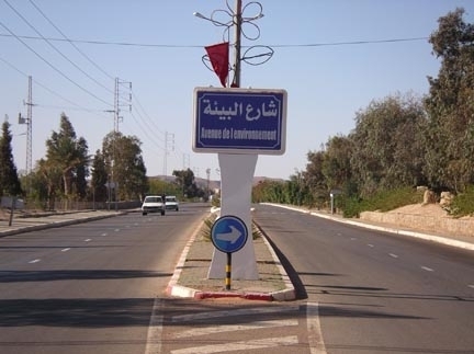
about year 2000, there was the "Year of the Environment". Not long
after that "Avenue de l'Environnement" or "Boulevard of the
Environment" started to appear in
many towns in Tunisia. Often these were major widening and
Back
about year 2000, there was the "Year of the Environment". Not long
after that "Avenue de l'Environnement" or "Boulevard of the
Environment" started to appear in
many towns in Tunisia. Often these were major widening and
 up-grades to the main
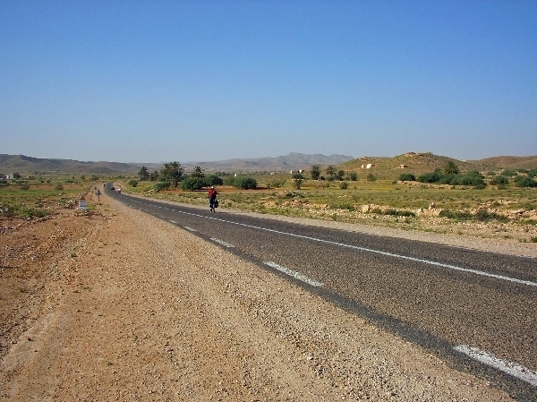
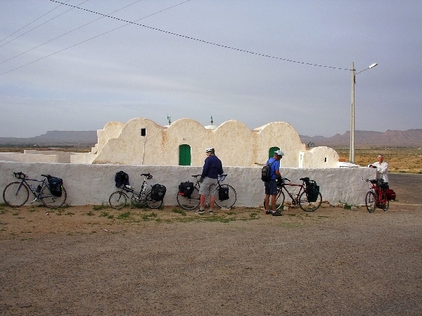
road in town. The first prominent sign on the route to Bir Lahmir -- an otherwise small, one intersection village on the highway
between Medenine and Tataouine -- proclaims "Avenue of the Environment."
Isn't there some irony in having more paving a commemorative project for
environmental awareness and protection?
up-grades to the main
road in town. The first prominent sign on the route to Bir Lahmir -- an otherwise small, one intersection village on the highway
between Medenine and Tataouine -- proclaims "Avenue of the Environment."
Isn't there some irony in having more paving a commemorative project for
environmental awareness and protection?
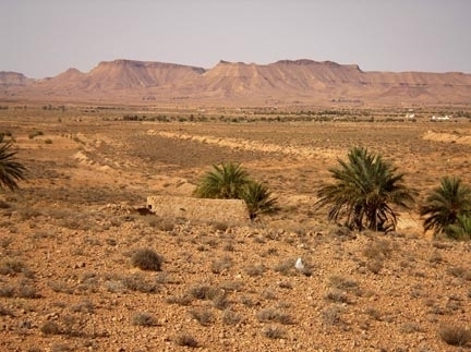
 The
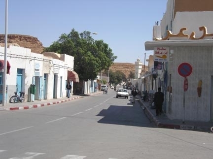
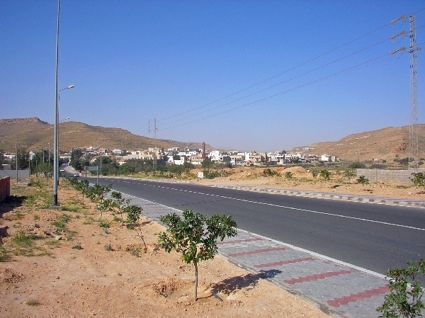
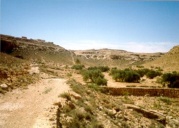
next leg is increasingly pleasant agricultural country with some small hills. The
next notably point of interest is the compact picturesque town of Ghomrassen,
which is wedged into the zig-zag gorge cut through the centuries by Oued
Ghomrassen (Ghomrassen River), At this time of year the river is dry, but the river bed
is wide enough to carry a lot of water. It suggests that when it rains
it pours. The wholly man Marabout Sidi Moussa
Ben Abdullah's whitewashed mausoleum sits above the town on the north hill and the towns large
ksar has a seemingly equally inaccessible perch on the cliff to the
south of town. The town is also considered the home of a sweet treat made
with honey, almonds and olive oil
The
next leg is increasingly pleasant agricultural country with some small hills. The
next notably point of interest is the compact picturesque town of Ghomrassen,
which is wedged into the zig-zag gorge cut through the centuries by Oued
Ghomrassen (Ghomrassen River), At this time of year the river is dry, but the river bed
is wide enough to carry a lot of water. It suggests that when it rains
it pours. The wholly man Marabout Sidi Moussa
Ben Abdullah's whitewashed mausoleum sits above the town on the north hill and the towns large
ksar has a seemingly equally inaccessible perch on the cliff to the
south of town. The town is also considered the home of a sweet treat made
with honey, almonds and olive oil
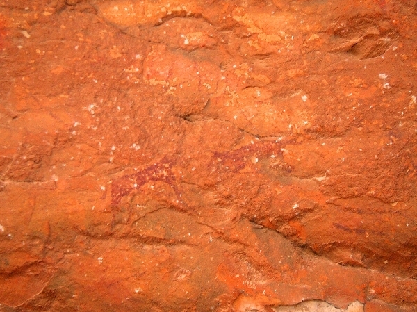
called the "corne de gazelle" (gazelle horn). To the west of the center of town, under a large over hang, are a series of old cave paintings, most showing animals.
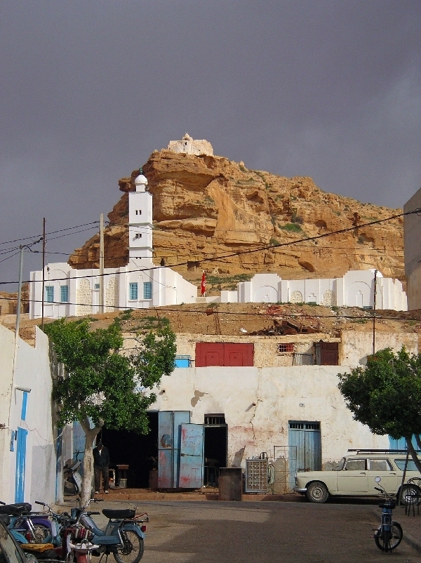
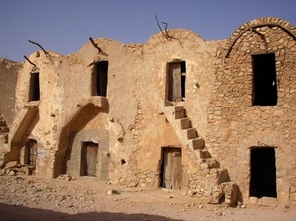
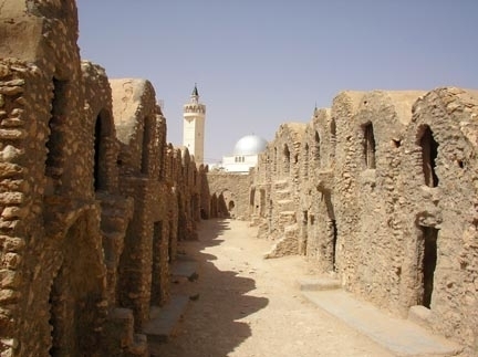
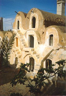 After
a another gentile six kilometer climb, we reach Ksar Hedada by
mid-morning. By Tunisian standards, Ksar Hedada is fairly
new at only a couple hundred years old. We check into the even newer hotel,
drop our stuff and had a snack. The hotel for the night is a converted
ksar.
The ghorfas (long barrel vaulted storage rooms which are stacked and walled
to form a ksar) have been fitted with beds and bathrooms. [Ed. note
2005:
the hotel has since closed
After
a another gentile six kilometer climb, we reach Ksar Hedada by
mid-morning. By Tunisian standards, Ksar Hedada is fairly
new at only a couple hundred years old. We check into the even newer hotel,
drop our stuff and had a snack. The hotel for the night is a converted
ksar.
The ghorfas (long barrel vaulted storage rooms which are stacked and walled
to form a ksar) have been fitted with beds and bathrooms. [Ed. note
2005:
the hotel has since closed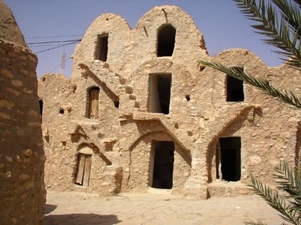 (see sidebar), but word in Ksar Hedada is it will open again by
2006. Ed. note 2007 and 2009: It is still not renovated for lodging and the
current word is that there are no plans to.]
(see sidebar), but word in Ksar Hedada is it will open again by
2006. Ed. note 2007 and 2009: It is still not renovated for lodging and the
current word is that there are no plans to.]
If it looks familiar you have probably seen one of the Star War movies. Ksar Hedada was used as the site of Tatawine (pronounced exactly like the Tunisian town, 20 kilometers southeast of Tataouine -- hardly original creativity) for 1997 movie "Star Wars the Phantom Menance".
 After
a break
at the hotel we headed out for Chenini, 12th century mountain top village. It is about a
thirty kilometer ride.
Most of the route there
After
a break
at the hotel we headed out for Chenini, 12th century mountain top village. It is about a
thirty kilometer ride.
Most of the route there
 is a delightful,
generally flat ride with nice views of farm lands and mesas. Along
the way we passed another relatively intact ksar at El
Firch and stopped to explore it for a bit. The combination of
symmetry and asymmetry, and the lighting, made the czar particularly
photogenic.
is a delightful,
generally flat ride with nice views of farm lands and mesas. Along
the way we passed another relatively intact ksar at El
Firch and stopped to explore it for a bit. The combination of
symmetry and asymmetry, and the lighting, made the czar particularly
photogenic.
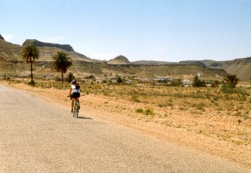
The scenery on this section of the ride was spectacular. A line of mesas and peaks extended for a miles to our right and on our left was a mountain top and sheer cliff with the ruined city of Chenini along the rim, a shining white mosque dominating the earth-toned houses. A young burro crossed the road to its mother directly before us with a young, barefoot girl right behind it, alternately shouting her displeasure to the burro and helloing us.
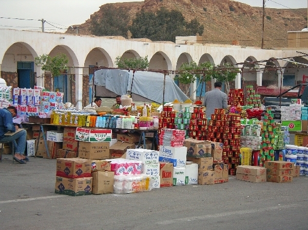
To get to Chinini, being on the top of a mountain, the last stretch has a hefty climb. At the top of the road were the tour buses with lounging drivers and a nice restaurant. It was now past noon so we made for the restaurant where we split three standard plates between the five of us and still paid almost twice as much per person as any meal so far. However, the meal was plentiful with cornes de gazelle as part of the deal.
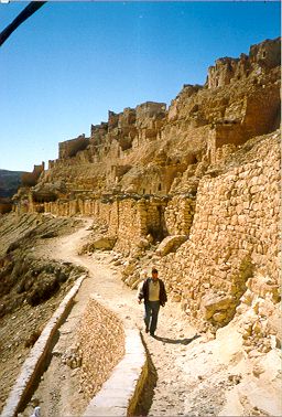
Afterwards, we made our way up the steep path to view the ruins of ksar Chenini, a twelfth century fortified hill village. There were as many vendors, inhabitants (for some of the structures have been renovated and are indeed still inhabited), and potential tour guides as there were tourists since this is not the high season. The ruined city is as impressive as its location lining the cliff. The view from the top went on for miles and miles.
All
around the mountain top trails switch back and forth along the faces to give people access
to the warren of homes.
 The homes are a mixture of stone
and clay-mortar houses and subterranean rooms, clinging to and dug into
the steep hillside. This was all done to provide protection from
raiding groups that would attach in the area. Now that raids are not a
threat,
The homes are a mixture of stone
and clay-mortar houses and subterranean rooms, clinging to and dug into
the steep hillside. This was all done to provide protection from
raiding groups that would attach in the area. Now that raids are not a
threat,
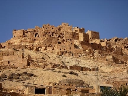 most residence have opted for the easier life and building
houses and lives in the flat lands at the foot of the mountain.
Consequently, the old
houses on the mountain are falling into disrepair, but it is still a remarkable site.
The best maintained building in the old hillside village is the mosque.
A few people also have businesses and maintain amusements, like a camel
powered oil press, for the benefit of the tourists. It is also the
first place where we encountered a concentration of children
persistently demanding
to be given money.
most residence have opted for the easier life and building
houses and lives in the flat lands at the foot of the mountain.
Consequently, the old
houses on the mountain are falling into disrepair, but it is still a remarkable site.
The best maintained building in the old hillside village is the mosque.
A few people also have businesses and maintain amusements, like a camel
powered oil press, for the benefit of the tourists. It is also the
first place where we encountered a concentration of children
persistently demanding
to be given money.
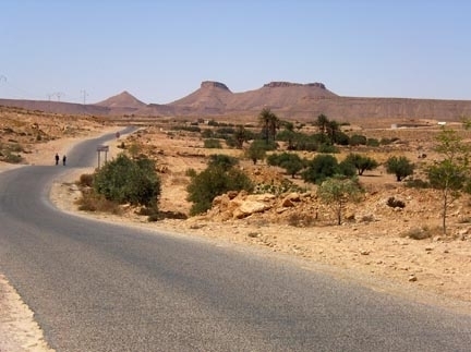
And what a ride that next seventeen kilometers was! A steep, but gently curved downhill with a strong tailwind to start and then a strong tailwind with rolling hills as intermezzo. Most of the small hills you could take by coasting over or briefly pedaling hard to the crest; only a few required us to downshift and again only briefly. Very pleasant.
 Returning to Ksar
Hedada, by a slightly shorter route (but with seven rough kilometers of
dirt road), we passed another similar 12th century village at
and above the
town of Guermessa. Except for the mosque this town has completely moved down to the flat lands.
Returning to Ksar
Hedada, by a slightly shorter route (but with seven rough kilometers of
dirt road), we passed another similar 12th century village at
and above the
town of Guermessa. Except for the mosque this town has completely moved down to the flat lands.
We proceed through some remarkable country with stark mesas and bluffs that could have been in a New Mexico-scape. However, the stone and cave houses that appeared from time to time belied this notion. For those who love the American southwestern vistas, this ride was picture perfect.
With a day full of good adventure we ate and slept well. Sleeping in a ghorfa is like sleeping in a thick clay cocoon – no sound or light penetrates to disturb you. They are quite cozy and romantic. But Tunisians probably think that tourists are crazy to pay to sleep in "storage bins."
If we had left in the other direction from Chinini, in twenty-two kilometers we would have reached Douiret, another hillside ksar. This is a very beautify section of road with river gorges, tessour, hills and valleys. It Douiret is less inhabited and more in ruins than Chinini, but still very interesting to poke around. One of its claims to uniqueness is a subterranean rock-hewn mosque.
Continuing another twelve kilometers and you will reach Ksar Ouled Debbab it has an impressive gorfa-style ksar that sits prominently on the hill about the town.
From Ksar Ouled Debbab it is ten kilometers to Tataouine or six kilometers to the junction of the road to Chinini and the road to El Ferch (six kilometers from Tataouine), completing a circle.
On one tour we tried a non-standard
route to Ksar Hedada. You'll learn why it is not the standard
route, but it makes a good story. It started out ordinary enough; we followed the
obvious route for the first twenty-five kilometers. At that point there was a
newly paved road to the right, which, on the map, looked like it should head
directly to Ksar Hedada, but it was not signed. Not far down the road I
spoke to a couple of men on a farm and we concluded that their comments and
jesters meant that we could get to Ksar Hedada by this road. After six
kilometers we came to a village and asked again. The message here was a
little more confused. No one was encouraging us to follow our route, but no
one was saying that it couldn’t be done. Clearly the
 road changed from paved to dirt, but it was in good shape, flat and gently
rolling, and fairly well travel. And it continued in the right direction.
Well, that could be said for the next three kilometers. Here the "road",
which had abruptly deteriorated, dropped into a dry river bed. The good news
was it spotted emerging from the river bed
road changed from paved to dirt, but it was in good shape, flat and gently
rolling, and fairly well travel. And it continued in the right direction.
Well, that could be said for the next three kilometers. Here the "road",
which had abruptly deteriorated, dropped into a dry river bed. The good news
was it spotted emerging from the river bed
a couple
hundred meters away. It had narrowed and was rocky but still headed the right
direction. That passes as the good news because the whole river valley was getting increasing narrow
and steep sided. Our trail traversed the hillside near the bottom.
Within the next kilometer of so it became clear that the valley was
dead-ending into a horseshoe-shaped cliff and we need to find a way up to the top of the
cliff and out. Conveniently, a solution appeared. At the head of the
canyon was what can best be described as a donkey trails,
switch-backing
up the cliff. We a little sweat we pushed the bikes
the several hundred meters to the top, walk through someone’s backyard and
front yard and out on to another paved road -- just a kilometer
north of Ksar Hedada.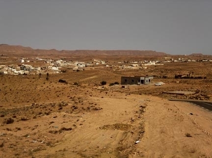 It would be hard for there to be a more direct route, but there
are definitely easier route.
It would be hard for there to be a more direct route, but there
are definitely easier route.
Ksar Hedada has fallen into disrepair since its closure as a hotel.
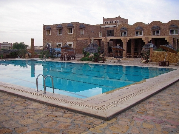
One alternative lodging to the closed Ksar Hedada is the three star
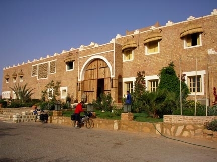 Dykanus, with one of the best hotel pools in Tunisia.
![]()
![]()

![]()
Unique Programs To Special Places For Memories Of A Lifetime!
![]()
![]() Please
write if you have questions, suggestions and comments about our program or want to be
added to Bicycle Africa's mailing list. (Also let us know how you found this site.)
Please
write if you have questions, suggestions and comments about our program or want to be
added to Bicycle Africa's mailing list. (Also let us know how you found this site.)