Ibike Korea People-to-People Program
 Photo essay: Yeongsan
River -
Photo essay: Yeongsan
River -
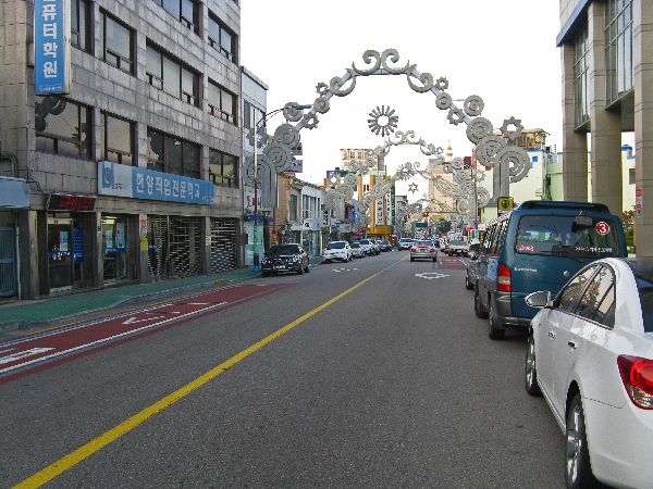
Gwangju, Naju, Mokpo
Yeongsan River Trail, (130 km, 80 mi) Mostly riverside and dike-top trail, with the occasional
headland.
Points of Interest: beautiful hills, rivers and valleys, Naju "Pear Town" , Mokpo "City of Lights"


 A
tributary of the Yeongsan River, the Gwangju River, flows into the center of Gwangju.
It generally doesn't connect many local destinations, but it provides local
recreational opportunities. In addition to the trail, there are exercise
equipment stations to enjoy.
A
tributary of the Yeongsan River, the Gwangju River, flows into the center of Gwangju.
It generally doesn't connect many local destinations, but it provides local
recreational opportunities. In addition to the trail, there are exercise
equipment stations to enjoy.

 Across
the river are more buildings for residential people stacking. As much as I
have trouble with the aesthetics of the residential complex and they are
sprawling, they cause a faction of the sprawl that would be the consequence of
all of the inhabitants living in single family houses.
Across
the river are more buildings for residential people stacking. As much as I
have trouble with the aesthetics of the residential complex and they are
sprawling, they cause a faction of the sprawl that would be the consequence of
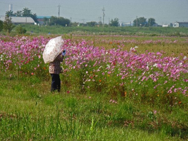
all of the inhabitants living in single family houses.In the open spaces along the river cosmos are a popular flower.

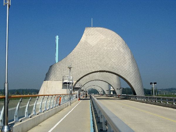
 Much
of Korean's river trail network is a component of the Four Rivers Project,
with the stated goal to provide or improve water security, flood control and ecosystem vitality.
It was first announced as part of the “Green New Deal” policy launched in January 2009.
Most of the work was completed by the end of 2012. More than a dozen dams or
large weirs are part of the system -- each with a distinctive look. This is Seungchonbo,
the largest weir in the nation. The shape of the overhead structure is suppose
to represent the end of a grain of rice, which is the dominate crop of the Naju
Plains.
Much
of Korean's river trail network is a component of the Four Rivers Project,
with the stated goal to provide or improve water security, flood control and ecosystem vitality.
It was first announced as part of the “Green New Deal” policy launched in January 2009.
Most of the work was completed by the end of 2012. More than a dozen dams or
large weirs are part of the system -- each with a distinctive look. This is Seungchonbo,
the largest weir in the nation. The shape of the overhead structure is suppose
to represent the end of a grain of rice, which is the dominate crop of the Naju
Plains.
 One
of the short coming of the river trails is that they are generally ahead of the
economy. That is the trails were built and people have come to use them but they
may not have many services like convenience stores, restaurants and lodging --
frequent restrooms generally have been included with the development of the
trail. The Seungchonbo/Naju area is an exception. The K-Water building
near the dam has a convenience store and tables that are very popular with trail
users. There is a new campsite near by, which in about 2014 started to pop up
sporatically near many of the river trails. And, Naju, especially in Samyeong-dong
and Ichang-dong, has many restaurants and small hotels.
One
of the short coming of the river trails is that they are generally ahead of the
economy. That is the trails were built and people have come to use them but they
may not have many services like convenience stores, restaurants and lodging --
frequent restrooms generally have been included with the development of the
trail. The Seungchonbo/Naju area is an exception. The K-Water building
near the dam has a convenience store and tables that are very popular with trail
users. There is a new campsite near by, which in about 2014 started to pop up
sporatically near many of the river trails. And, Naju, especially in Samyeong-dong
and Ichang-dong, has many restaurants and small hotels.
 Something
for the cute-animal lovers here. I am sure these guys would prefer to be
running free in the forest than trapped in their barren cages, but it was nice
to get a peak at them. The sign says "Yeongsan River Riding Club (Bear Deer
Farm)." I can't find any thing on a Bear Dear. The indigenous deer in
Korea are: Siberian Musk Deer, Red Deer, Sika Deer, and Siberian Roe Deer. In
size and shape it is closest to the Red Deer, but the fir and color are very
different -- it might be a summer coat.
Something
for the cute-animal lovers here. I am sure these guys would prefer to be
running free in the forest than trapped in their barren cages, but it was nice
to get a peak at them. The sign says "Yeongsan River Riding Club (Bear Deer
Farm)." I can't find any thing on a Bear Dear. The indigenous deer in
Korea are: Siberian Musk Deer, Red Deer, Sika Deer, and Siberian Roe Deer. In
size and shape it is closest to the Red Deer, but the fir and color are very
different -- it might be a summer coat.
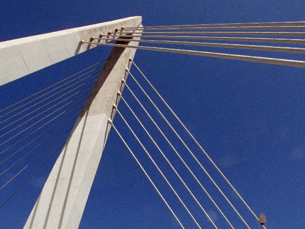
 New
"harp design" cable-staybridge at Naju. (left)
New
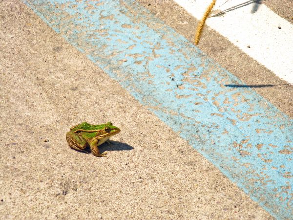
"harp design" cable-staybridge at Naju. (left)There was also some real wildlife -- a frog -- who pick a perilous resting place. Fortunately traffic was light. Hopefully he moved along in a timely manner.
 Seungchonbo
is about 25km from Gwangju and Ichang-dong, Naju, is about 35km from Gwangju so
they are popular turn around points from bicyclists on day trip out of Gwangju.
The next popular node is Juksan Dam which is another 10km south on the trail,
but it lacks any amenities, except restrooms and a drinking fountain.
Seungchonbo
is about 25km from Gwangju and Ichang-dong, Naju, is about 35km from Gwangju so
they are popular turn around points from bicyclists on day trip out of Gwangju.
The next popular node is Juksan Dam which is another 10km south on the trail,
but it lacks any amenities, except restrooms and a drinking fountain.


 The
view from Najupyeongya Pavilion and view
point, south of Naju, makes it worth a stop.
The
view from Najupyeongya Pavilion and view
point, south of Naju, makes it worth a stop.


 This
is the Juksanbo (weir) on the Yeongsan River. It is debated whether
the new weirs have been more destructive or constructive for the environment.
Some assert that the real objective of the project was for the then President to
pay back his industrialist friends. All of the major
corporations got a piece of the pie. The politics aside, recreational bicycle is
a winner.
This
is the Juksanbo (weir) on the Yeongsan River. It is debated whether
the new weirs have been more destructive or constructive for the environment.
Some assert that the real objective of the project was for the then President to
pay back his industrialist friends. All of the major
corporations got a piece of the pie. The politics aside, recreational bicycle is
a winner.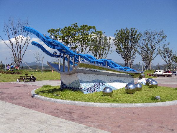


 At
Juksanbo they have included some art, including a playful piece of a bicycle
build for two, being chased by couple of pink dogs.
At
Juksanbo they have included some art, including a playful piece of a bicycle
build for two, being chased by couple of pink dogs.The other major piece has blue waves and silver balls, which are left to your imagination.


 While
much of the trail was in the flood plain or on the top of adjacent dikes, there
were notable sections that required a special effort and specific engineering.
This was often when the river abutted a steep hillside. Occasional the
trail on raised viaducts specially built for the purpose (right).
While
much of the trail was in the flood plain or on the top of adjacent dikes, there
were notable sections that required a special effort and specific engineering.
This was often when the river abutted a steep hillside. Occasional the
trail on raised viaducts specially built for the purpose (right).


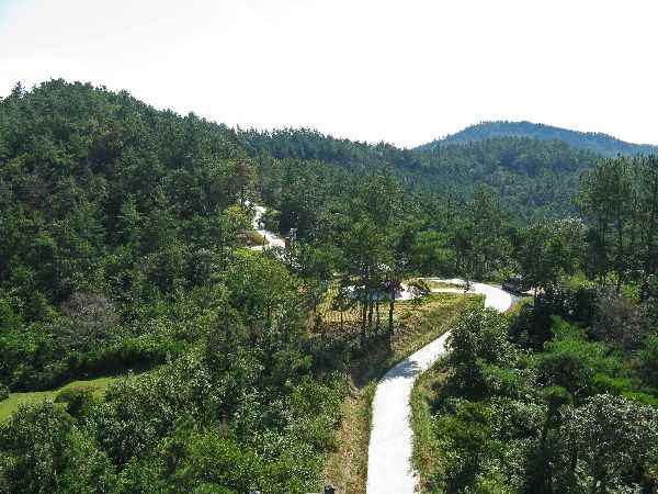
 Sometimes
there were no flood plains or dikes and the cliffs were too steep and long so
the trail detoured on to farm roads and through farmlands and villages. It is a
welcome diversion. The farm roads were built to suit the farmers, not the
end-to-end trail users, so for the trail user they often had some interesting
twists and turns to stay on course. Generally these were well marked -- if
you were looking at the right place at the right time. The one in the
shade on the pavement were easier to fly by. Big ones on post were hard to
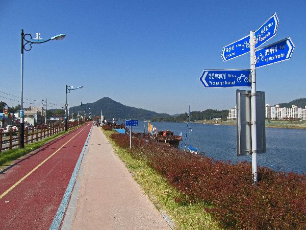
miss. The trail signage is interesting because there are several different
systems going on; one covers end-to-end information and other schemes are just
for a district. At times it is hard to reconcile the numbers from the
different systems. Have a little skepticism for numbers can be a health trait
for bicyclists -- if you follow the route and ride you will get there in due
time.
Sometimes
there were no flood plains or dikes and the cliffs were too steep and long so
the trail detoured on to farm roads and through farmlands and villages. It is a
welcome diversion. The farm roads were built to suit the farmers, not the
end-to-end trail users, so for the trail user they often had some interesting
twists and turns to stay on course. Generally these were well marked -- if
you were looking at the right place at the right time. The one in the
shade on the pavement were easier to fly by. Big ones on post were hard to
miss. The trail signage is interesting because there are several different
systems going on; one covers end-to-end information and other schemes are just
for a district. At times it is hard to reconcile the numbers from the
different systems. Have a little skepticism for numbers can be a health trait
for bicyclists -- if you follow the route and ride you will get there in due
time.


 Along the trail there are a numbered set of special scenic places. Most of
these are manmade, for example bridges, weirs, and historic pavilions.
Bokryong Observatory, "Viewing Spot #3" (starting from Mokpo), is unique in that it quality relies predominantly on
natural beauty; the bend in the river and the hills around it. It is the
nicest single view of a very pretty day.
Along the trail there are a numbered set of special scenic places. Most of
these are manmade, for example bridges, weirs, and historic pavilions.
Bokryong Observatory, "Viewing Spot #3" (starting from Mokpo), is unique in that it quality relies predominantly on
natural beauty; the bend in the river and the hills around it. It is the
nicest single view of a very pretty day.
As is so often the case another variation on rice field comes into view. This one with relatively closely spaced terraces providing a mix of lines, color, texture and content.


 In
the small village of Cheongho-ri a few simple fishing boats are pulled up on the
shore, but just around the corner thousands of cars and trucks rush across the
ultra-modern Mokpo-Gwangyang Expressway Bridge (Hwy 10). It is a triple span,
cable stay bridge, that sweeps across the
river
In
the small village of Cheongho-ri a few simple fishing boats are pulled up on the
shore, but just around the corner thousands of cars and trucks rush across the
ultra-modern Mokpo-Gwangyang Expressway Bridge (Hwy 10). It is a triple span,
cable stay bridge, that sweeps across the
river
 Which
brings us to underwhelming Viewing Spot #1 on Yeongsanho (lake) View Point.
The view point itself is a set of barren, raised curved walkways, with no shade.
The lake is a broad expanse surrounded by low hills of flat lands. Objects
that catch the eye are the nets of the golf driving range in the southern part
of Mokpo, the Mokpo-Gwangyang Expressway Bridge and the relatively featureless
Yeongsan River Estuary Dam. Maybe I was just too tired from fighting a
headwind when I was here to
properly appreciate it. And, in its defense, it is supposed to be at its best at
sunset.
Which
brings us to underwhelming Viewing Spot #1 on Yeongsanho (lake) View Point.
The view point itself is a set of barren, raised curved walkways, with no shade.
The lake is a broad expanse surrounded by low hills of flat lands. Objects
that catch the eye are the nets of the golf driving range in the southern part
of Mokpo, the Mokpo-Gwangyang Expressway Bridge and the relatively featureless
Yeongsan River Estuary Dam. Maybe I was just too tired from fighting a
headwind when I was here to
properly appreciate it. And, in its defense, it is supposed to be at its best at
sunset.


 Namchang Bridge is a "harp design"
cable-stay bridge, as is the Mokpo-Gwangyang Expressway Bridge -- not to be
confused with suspension bridges. The Yeongsan River Trail crosses the
Namchang Bridge at the edge of Mokpo. Because of the simple and elegant lines
cable-stay bridges have become very popular.
Namchang Bridge is a "harp design"
cable-stay bridge, as is the Mokpo-Gwangyang Expressway Bridge -- not to be
confused with suspension bridges. The Yeongsan River Trail crosses the
Namchang Bridge at the edge of Mokpo. Because of the simple and elegant lines
cable-stay bridges have become very popular. 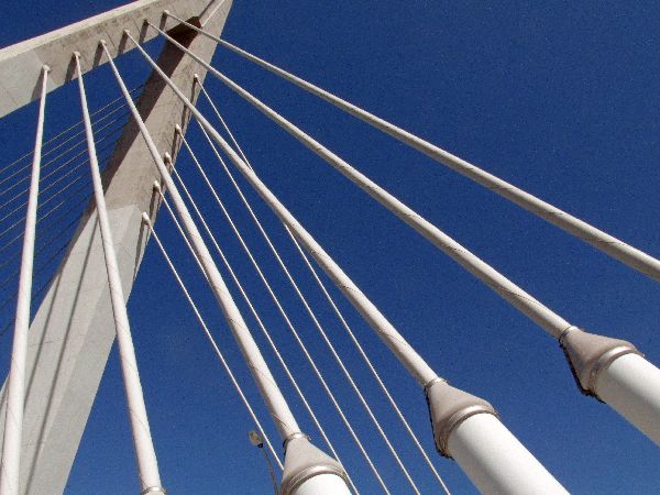
 These invite some architectural art photography.

 The Mokpo
Ogam Wetland Ecological Park is bounded on one side by the Yeongsan River Trail
and the other by a large high rise residential development and golf driving
range.
The Mokpo
Ogam Wetland Ecological Park is bounded on one side by the Yeongsan River Trail
and the other by a large high rise residential development and golf driving
range.
At the side of the ecological park is a demonstration or test of four types
of wind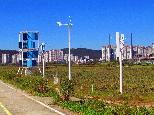 powered electric generators; straight vertical vane style, three-blade propeller
style, curved vertical vane maglev style and horizontal bucket vertical axis
style.
powered electric generators; straight vertical vane style, three-blade propeller
style, curved vertical vane maglev style and horizontal bucket vertical axis
style.
Another Mokpo Urban Wetland Park is proposed for the shoreline just west of the museum complex. It was a manmade rectangular boat harbor and rectangular lagoon, that are being filled and reclaimed (or claimed.)
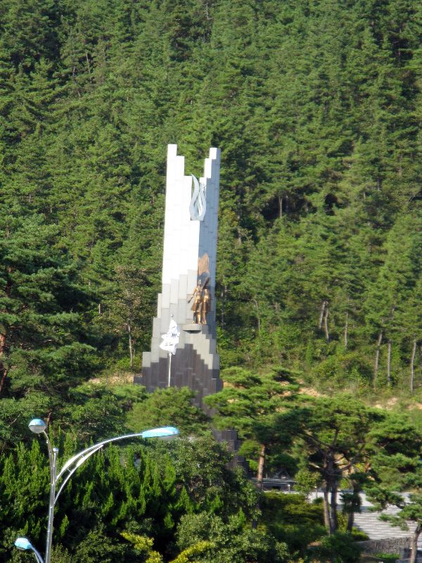
 monument is perhaps 50 feet tall with the figure of two women holding a Korean
flag. There is a museum underneath it. There is also access to hiking trails
that go up the mountain to the north and offer great panoramic views of the
eastern part of the city.
monument is perhaps 50 feet tall with the figure of two women holding a Korean
flag. There is a museum underneath it. There is also access to hiking trails
that go up the mountain to the north and offer great panoramic views of the
eastern part of the city.Mannam Waterfall is an artificial waterfall on the side of Mt. Buheungsan at the southern terminus of the Yeongsan River Trail and the entrance to town. At night it is lit with colored lights.

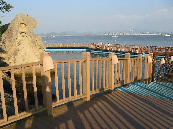 Gatbawi,
"Hat Rock" or "Lampshade Rock", is a natural Sandstone and Tafoni formation found on the shore of
the East Harbor. It resembles a Joseon Era helmet to some and a satgat
(conical woven hat) to others. Because the formation is created from wave
action, the best view is from the bay side. To resolve the access problem
for ordinary citizens a beautiful walkway was built around the formation.
Gatbawi,
"Hat Rock" or "Lampshade Rock", is a natural Sandstone and Tafoni formation found on the shore of
the East Harbor. It resembles a Joseon Era helmet to some and a satgat
(conical woven hat) to others. Because the formation is created from wave
action, the best view is from the bay side. To resolve the access problem
for ordinary citizens a beautiful walkway was built around the formation.
There are two legends associated to Gatbawi:
A long time ago, a young man lived with his sick father and sold salt. Though he was poor, he was a kind man who would do anything to help his sick father.
To earn and save money to cure his father’s illness he worked as a farmhand for a rich house. He did his job well but in the end the wealth man didn’t pay him.
When he returned home after one month, he found his father’s body was already cold. The boy had great regrets. The least he could do was to try to make his father comfortable in the afterlife. Unfortunately, as he was moving his father’s body, he slipped and dropped the coffin into the sea.
He now felt awful about his father’s underwater burial. To make amends, he stayed until he too could no longer see the sky. A long time after his death, two rocks rose up at Gatbawi: The bigger rock is called the “father” and the smaller is called the “son”.
The second legend says that when Buddha and a disciple traveled across the Yeongsan River, they took a rest in this place. When they continued on their journey, they left behind their hats. This gives rise to the alternative name of “monk rocks.”

 The Mokpo Maritime Memorial is between
the National Maritime Museum and the Art and
Culture Center -- part of a complex of museums. The National
Maritime Museum houses a relic museum and the Maritime Cultural Asset Research
Institute, which is the nation's only institute for underwater archaeology. The
museum recovers relics that were lost underwater hundreds of years ago for the
purpose of preservation and exhibition. In the exhibits guests learn about the
exploration of a trade ship that sank off the coast of Korea between the 11th
and 14th century and the Goryeo celadon relics that were recovered during the
exploration. In addition to the indoor pieces, an exhibit of full-sized Korean
traditional ships is on display on the waterfront outside the museum.
The Mokpo Maritime Memorial is between
the National Maritime Museum and the Art and
Culture Center -- part of a complex of museums. The National
Maritime Museum houses a relic museum and the Maritime Cultural Asset Research
Institute, which is the nation's only institute for underwater archaeology. The
museum recovers relics that were lost underwater hundreds of years ago for the
purpose of preservation and exhibition. In the exhibits guests learn about the
exploration of a trade ship that sank off the coast of Korea between the 11th
and 14th century and the Goryeo celadon relics that were recovered during the
exploration. In addition to the indoor pieces, an exhibit of full-sized Korean
traditional ships is on display on the waterfront outside the museum.
 The
blocks and streets around the fishing boat harbor tell the story; Spicy Monkfish
Street, Seonchang Raw Fish Center, Raw Croaker Street, Dried Fish Store, and the
Mokpo Wholesale Fish Market.
The
blocks and streets around the fishing boat harbor tell the story; Spicy Monkfish
Street, Seonchang Raw Fish Center, Raw Croaker Street, Dried Fish Store, and the
Mokpo Wholesale Fish Market.Berthed at the mouth of the harbor is a large Korea Coast Guard ship.

 Mokpo
newest (2012) landmark is the double tower, 1.75km long, "fan design" cable-stay
Mokpo Bridge (left) at the mouth of the Yeongsan River. It is the second longest
cable-stayed bridge in Korea. The main span is 500m long. The bridge was
designed by Seoul based GS Engineering & Construction.
Mokpo
newest (2012) landmark is the double tower, 1.75km long, "fan design" cable-stay
Mokpo Bridge (left) at the mouth of the Yeongsan River. It is the second longest
cable-stayed bridge in Korea. The main span is 500m long. The bridge was
designed by Seoul based GS Engineering & Construction.
Five kilometers north is the 1.5km long, Aphae Bridge (right), which was completed in 2008. It connects the mainland with Aphae Island.


 Please
contact us if you would like to be added to
Ibike's mailing list or have questions, comments, corrections or criticism. (Also, please let us know how you learned about us and
found this site.) Privacy policy.
Please
contact us if you would like to be added to
Ibike's mailing list or have questions, comments, corrections or criticism. (Also, please let us know how you learned about us and
found this site.) Privacy policy.
![]() IBF Homepage
IBF Homepage ![]() Ibike Programs
Ibike Programs
![]() Ibike Schedule
Ibike Schedule
![]() Search
Search